Friday, December 16, 2011

"Iron Bridge Trail" Penstock Trail

This was a fun little hike we went on right outside Leavenworth west on Hwy 2. This trail follows an old Penstock that delivered water to a power house. 
The bridge crosses the Wenatchee river, and was very icy!


We found some interesting ice formations at the end of the trail


Monday, October 10, 2011

Sockeye Salmon Spawning on the Cle Elum River


If you travel to the Salmon la Sac campground in the fall, I'm sure you will see spawning Sockeye. Just look down off the bridge that crosses the Cle Elum River. I went there twice this fall, the first time was the last week in September and I saw over 50. I went again the second week in October and we only saw about 20. It was an awesome experience. It's incredible how far they travel during their lifetimes only to return where they were born. 


Looking up at the Cle Eum River bridge

Cooper River Trail


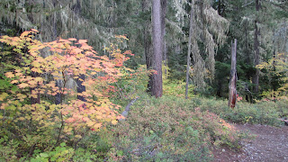
This hike was a pleasant surprise. We went to the Salmon La Sac Campground at the end of 903 to watch the Sockeye Salmon spawn. We did see about 20, looking down from the Salmon La Sac bridge that crosses the river (I will post pictures in a different post). So we did that and then kept driving to the trail head for Cooper River. The hike follows the river for 3 miles where it ends at Cooper Lake (which you can drive to). We didn't go to the lake today, as we have been there many times before. The trail has some moderate up and down climbs. The Vine Maple were turning and the air was slightly crisp so it defiantly felt like fall. We saw a few large fish in one of the pools towards the beginning of the hike, I'm not sure what they were maybe someone else will know?

Keep your eyes peeled for little tree frogs

Round Trip
6 miles

Directions
Take exit 80 off of I-90. Travel north on SR 903 about 15 miles until you reach Salmon la Sac, take the left branch in the road that travels over the Cle Elum River bridge and then turn right, heading away from the campground and you will reach the trail head parking in 1/2 mile. 

Sunday, October 9, 2011

Cowiche Canyon


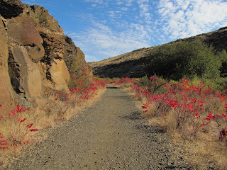
This was a beautiful fall hike. This trail was a rails-to-trails project, and took many years to complete. Brilliant fall colors from the Sumac lined the trail. About a 3 mile walk each way it crosses Cowiche Creek in several places. 

Here are some pictures for your viewing pleasure....


"Would you look at that!"

We saw a total of 3 rattlesnakes resting on the trail! So awesome! (don't worry I used my zoom, so I wasn't that close)


A beautiful fall day, perfect for a little hike with the hubby!

Directions:
From Ellensburg, drive east on Interstate 82 to exit 31A to get on westbound US 12. Take the second exit off US 12 --the exit is signed "N. 40th Ave. and Fruitvale Blvd." Drive under the freeway, across Fruitvale, and in 1.5 miles from US 12 turn right onto Summitview. Continue for 7.1 miles and turn right on Weikel Road (signs on Summitview indicate Cowiche Canyon turnoff). Drive 0.4 mile on Weikel Road, and turn right at the sign for Cowiche Canyon.

Sunday, August 14, 2011

Esmeralda Basin Hike

This was a beautiful moderately easy hike. We went on a Sunday and OH MY!! I have never been there when it was so crowded, there had to have been 100 cars. We always go near the end of September/October to see all the Larch trees turning and there's usually 5 cars. needless to say this place was like a trail freeway. That detracted from the "magic" of it all. It was still incredibly beautiful. Lots of little meadows off the trail that were packed full of color. A number of small stream crossings and at 3.5 miles you look down from the un-named pass at Lake Ann. We did not go this far today, as our primary intrest was hiking slowly and checking out all the flora. We would love to go back on a day thats not so crowded.
Chipmunk snacking by some Columbine Flowers
The trail follows this river for awhile
Enchantment Peaks
Columbine
Fairy Trumpet Flower
Monkshood
Even the dogs have to pack their own weight!
 Princes Pine
 My hubby/hiking buddy :)

 Elephanthead lousewort
 Bog Orchid
 Another Columbine
Columbia lewisia
 I'm not sure what this little guy is but it looks like he has a heart on his back!

Watch out for the aggressive mountain goats, we didn't see any
Directions:
Take SR 970 north to the Teanaway Road. Follow the North Fork Teanaway Road where the pavement ends. Take the right fork, FR 9737, 10 miles to its end at trailhead #1394, Esmeralda Basin. 

Round Trip to Un-Named Pass:
7 miles

Wednesday, July 27, 2011

Photos!

We haven't been on any great hikes lately, been too busy with family trips but here's a few pictures that I took recently. 
A pretty mint flower of some kind
Foxglove
A slug munching on a buttercup
Fresh picked daisies!
A Bull Elk I saw in the Valley
Swallowtail on a Musk Thistle

Tuesday, June 28, 2011

Umtanum Falls

 This is a great little hike near Ellensburg. We have been up here countless times, on our own time and with some classes in college. Its a great place for Plant taxonomy, Entomology and even herpetology (we didn't find any herps this trip) With all the flooding that occurred the end of May and June the falls were quite large (compared to just a trickle later in the summer)
Here are some things you can find on the trail:
A patch of Camas
Death Camas:
Larkspur: Delphinium nuttallianum


Thompson's Indian Paintbrush:

Arrowleaf Balsamroot: Balsamorhiza sagittata
Locoweed:
Prairie Star:

About 2 miles round trip